
Home > Apps > Photography > GPS Map Camera App

| App Name | GPS Map Camera App |
| Category | Photography |
| Size | 5.00M |
| Latest Version | v1.1.6 |


The GPS Map Camera App is a powerful tool that seamlessly integrates the capabilities of a camera with advanced GPS location tracking. This innovative application enables users to create a comprehensive visual diary of their journeys through features such as geotagging, GPS scanning, and GPS mapping. One of its standout features is the robust mapping system, which allows users to plot their photos onto a GPS map, providing an engaging way to revisit their adventures. Moreover, the app extends its functionality by allowing users to add precise GPS location data to photos they've already taken, making it incredibly versatile for creating a personalized photo map based on location.
Designed with user-friendliness in mind, the GPS Map Camera App works seamlessly with GPS-enabled devices, catering to both professional photographers and casual users who love capturing moments on the go. By enhancing your photos with geolocation data, this app transforms your photography into an interactive experience.
Key Advantages of the GPS Map Camera App
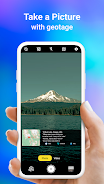
- Integrated Camera and GPS Tracking: The app ingeniously combines camera functionality with GPS location tracking, enabling users to take photos that are automatically tagged with detailed geolocation data, effectively chronicling their travels.
- Versatile Photo Capture and Tracking Options: Users have the flexibility to either use the built-in GPS camera to take new photos or enhance existing photos with geotagging and GPS location data, ensuring every picture tells a story of where it was taken.
- Advanced Mapping System: With its robust mapping capabilities, the app allows users to view their entire collection of photos on a GPS map, making it simple to visualize the journey and pinpoint the exact location where each photo was captured.
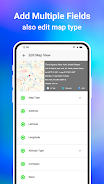
- Customizable Date and Timestamp Formats: Users can personalize their photos further by choosing and adding specific date and timestamp formats, adding another layer of detail to their visual records.
- Photo Naming and Navigation Features: The app offers the ability to customize photo names and provides live navigation features, which helps in organizing and navigating through your photo collection with ease.
- Lightweight Option Available: For users concerned about storage, the Lite version of the GPS Map Camera App provides many of the same powerful features in a more compact package, ensuring you can enjoy the app without sacrificing much-needed space on your device.
-
 Best MLB The Show 25 Diamond Dynasty Cards & Lineups (March 2025)
-
 Animal Crossing: Pocket Camp Complete - How to Unlock Lobo
-
 Archero 2 Tier List – Ranking the Best Characters in February 2025
-
 Epic Games Unveils Free Bridge Constructor: The Walking Dead and Idle Champions Rewards
-
 Veilguard DLC Delayed for Mass Effect 5
-
 Marvel vs Capcom 2 Original Characters May Show Up in Capcom Fighting Games